07.06.2022
What happens with location data after they have been generated?

Favendo is a solution provider for real-time positioning solutions. But what exactly does that mean? What exactly are Real Time Location Services? And what do I get out of RTLS in the end? Do I perhaps need third-party providers to achieve goals such as process optimization or increased profitability? Because one thing is for sure: In environments as complex as modern manufacturing, for example, rarely does only one technology and one solution lead to the goal. Rather, it is the combination and addition of solutions that provides the desired added value and, above all, makes the digital system permanently scalable.
That’s why Favendo, as a solution provider for RTLS, has specialized in the generation of location data. This means that we provide the software and hardware needed to locate objects and people and output this data in such a way that it can be processed further without any problems. In addition, we take care of the planning of the infrastructure and handle the installation and rollout. In practice, this would look like this, for example:
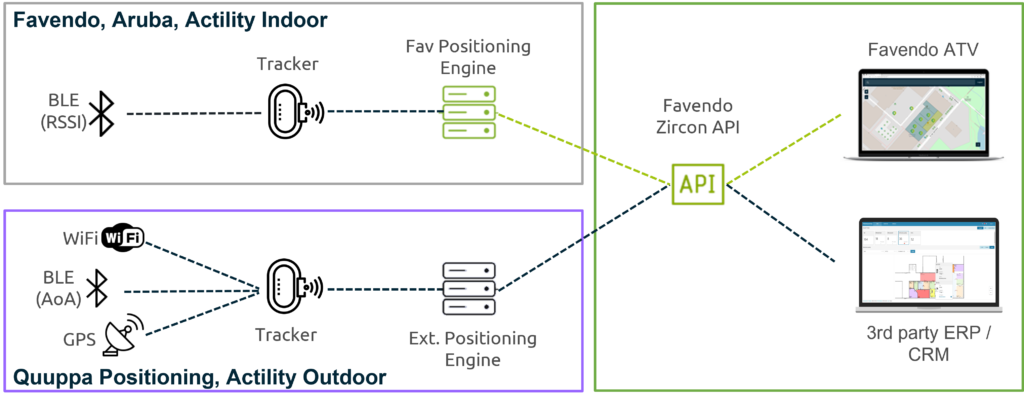
In a production hall, reusable containers that are filled with the finished parts at the end of a production line are to be tracked. This means Favendo equips the movable assets, i.e. the containers, with an asset tag, for example a beacon. This can be bolted to the box or simply attached with cable ties or double-sided tape. Additional trackers are placed in the room (preferably on the ceiling or at higher positions). These should always be planned and mounted with regard to the local conditions and possible signal interference. The trackers receive the signals from the beacons and forward them to the positioning engine, in Favendo’s case the Favendo Commander Engine. This is where the real magic happens, because this is where the position of the tagged containers is calculated based on the signals. And the more accurate the planning of the position of the trackers was in advance, the more accurate the calculation of the position data will be. Once this is done, the location data of the containers is output via our open API. From this point on, there are two ways:
- To visualize the tracking data and reduce search times in day-to-day business, Favendo offers the Viewer tool, which optimally supports end users in searching for assets.
- Alternatively, the data can be fed into third-party systems. This includes ERPs such as SAP or Oracle, but also AI-powered applications or analytics dashboards. This is particularly useful when it comes to process optimization.
With the help of a good strategy, the right partners and flexible technologies, you can not only digitize your processes step by step, but above all optimize them.